Local towns and villages are full of historic buildings – these are just some of the many that welcome visitors.
National and local organisations care for them and provide public access. Kate Knights, the Broads Authority’s Historic Environment Manager, works closely with them. Kate gives us a glimpse here of what interests her most about the Broads landscape and some of the buildings within it.
“Formed by a series of peat workings, the Broads is effectively one large archaeological site – demonstrating the scale of industry in the area in the medieval period. Peat was dug out to use as fuel, then later rising water levels flooded the peat diggings, forming the broads. Today, the series of broads that were formed shape our landscape and provide a beautiful and fascinating setting for many other historic sites. One of my favourites is Burgh Castle Roman fort, close to Burgh Castle village. Being able to get up close to such historic masonry is fantastic, and due to its strategic position, there are immense views over the rivers Waveney and Yare and Halvergate Marshes from the fort walls.
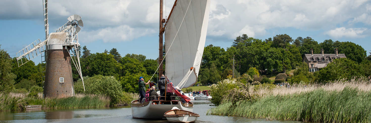
“And if the view inspires you to take a closer look at Halvergate Marshes, the Halvergate Mills Trail is a good place to start. The marshes have their own unique character and are definitely the place to go if you want to get away from it all. The 19th-century drainage mills are significant landmarks here and it’s interesting to see how they all differ as technology improved throughout the century. It’s strange to think that what is now such a quiet and tranquil landscape was once full of industry, with numerous mills, their sails turning, and water being moved from one place to another.
“At the Polkey’s Mill site (near Reedham), run by the Norfolk Windmills Trust, you can see the whole chronology of mill development. The site is visible from the Wherryman’s Way footpath and there are occasional open days.
“Back in the 16th century, Norfolk was much more densely populated than it is now and Norwich was England’s second largest city after London, in terms of the amount of tax it raised. All this wealth came partly from the wool trade and many wealthy, sheep-farming landlords built churches as symbols of their achievements. The Broads has many lovely flint churches, some with round towers and some with thatched roofs. Belaugh and Horning churches even have their own staithes where you can moor your boat when visiting.
“One theme common to most of the historic sites open to visitors is their relationship with the landscape and nature. This means that whether you’re interested in history, architecture or nature, or just want to get the kids out in the fresh air, the sites below (and a boat you can visit too) should provide something for everyone!”
Burgh Castle, River Waveney
One of the best-preserved Roman monuments in East Anglia, and one of the most impressive Roman buildings to survive anywhere in Britain. Dating from the 3rd century, it was one of the chain of Saxon Shore forts, built to defend the coast of south-east England. Breydon Water, close by, is the remains of the Great Estuary at Burgh Castle, when the sea came much further inland. The site is accessible to wheelchair users.
- Feeling hungry? The Fisherman’s Inn is close to the castle site.
- Ready to explore some more? The medieval round-tower church of St Peter and St Paul is part of the site.
Halvergate Mills Trail, Halvergate Marshes, River Yare
This walking trail is new but the six mills are far from new. They all date from the 19th century and were built to drain the vast area of marshes known collectively as Halvergate Marshes to keep it dry enough for grazing cattle. You can start the walk from Berney Arms Station, the moorings at Berney Arms or from the villages of Halvergate, Wickhampton or Reedham.
- Feeling hungry? Hope you’ve got a picnic – once you’re out on the marshes there’s no food for miles around.
- Ready to explore some more? Take the train to Great Yarmouth, which has many historic buildings, including the remains of the medieval town walls.
Hardley Cross, River Chet
The original wooden Hardley Cross, near the moorings, was erected in 1543, marking the ancient boundary of the legal powers of the City of Norwich and the Borough of Great Yarmouth. The cross probably also marked the original limit of Breydon Water. For hundreds of years officials from Norwich and Great Yarmouth sailed here by wherry for an annual ceremony to settle disputes relating to trade on the River Yare. The present cross is thought to date from 1676. To walk there, follow the path along the right-hand side of Hardley Dyke, as you face down it, towards the River Yare.
- Feeling hungry? Try Rosy Lee’s in Loddon.
- Ready to explore some more? Hardley Windmill is open to visitors when the sails are turning.
Cow Tower, Norwich, River Wensum
The tower was built in 1398-9 to control a strategic point in the defences already encircling medieval Norwich, the approach to the city across the River Wensum. It’s one of the earliest purpose-built artillery blockhouses in England. The ground floor may have been a communal dining room when the tower was garrisoned, with sleeping quarters on the upper two levels. The exterior of the tower is easily accessible on flat paths.
- Feeling hungry? The cathedral’s Refectory Bakery and Cafe is close by. During the summer, teas are available on Saturday and Sunday afternoons at Pull’s Ferry, just along the Norwich Riverside and Cathedral Quarter Walk, going towards the station.
- Ready to explore some more? Explore in either direction on Norwich’s Riverside Walk.
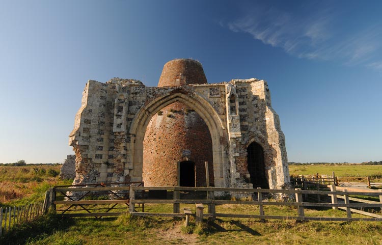
St Olave’s Priory, St Olave’s, River Waveney
The priory is named after the patron saint of Norway and dates from the 13th century. Part of the church, cloister and refectory survive. It’s a lovely site to wander around – and look out for dragonflies sunning themselves in the summer months.
- Feeling hungry? Priory Farm Restaurant is next door or try The Bell pub in the village.
- Ready to explore some more? Somerleyton Hall Gardens aren’t far away.
Bungay Castle, River Waveney
The market town of Bungay is tucked into a wide meander of the river. In 1103, the castle site (in the town centre) was given by Henry l to Roger Bigod, beginning a tumultuous phase of ownership by the Bigod family. From 1140 stone fortifications began to appear on the site, begun by Hugh Bigod, the youngest son of Roger Bigods’s heir. The remains of the early medieval castle, including its keep and gatehouse, and the substantial remnants of the site's defensive earthworks are still there. At present the site can only be viewed externally as extensive repairs are needed to make it safe.
- Feeling hungry? Bigod’s Kitchen cafe guards the entrance.
- Ready to explore some more? Bungay’s 17th-century Butter Cross is in the centre of the Market Place – a weekly market still takes place each Thursday, and you can also see St Mary’s Church and the Benedictine priory ruins that lie behind it.
St Helen’s Church, Ranworth, River Bure
One of the largest and finest Broads churches is St Helen’s at Ranworth – the present building dates from the 14th century. It is known as the Cathedral of the Broads and is famous for its screen and antiphoner – a beautiful illuminated service book written in Medieval Latin and produced around 1460 in Norwich. You can even climb the church tower for a bird’s-eye view of the Broads.
- Feeling hungry? You’re in luck, the church has its own Visitors Centre with tea shop and there’s also The Granary tearoom and The Maltsters pub in the village.
- Ready to explore some more? South Walsham, close by, has two churches, one is now an arts centre.
St Benet’s Abbey, near Ludham, River Bure
Religious hermits may have lived at the abbey site as early as the ninth century. What is certain, is that in 1019 King Cnut granted land and property to the hermits at St Benet’s and the Benedictine monastery began its long life. Monastic life was one important factor in the very creation of the broads. Many monastic houses held the rights to cut turf (or peat) in neighbouring parishes. In 1535, King Henry VIII gave the Bishop of Norwich the lands of St Benet’s and the title of abbot in return for other lands held by the bishop. As a consequence the abbey was the only one in England never to be formally dissolved. The Bishop of Norwich is still the Abbot of St Benet’s and each summer an open-air service takes place at the abbey, with the bishop arriving on a sailing wherry. Everyone is very welcome to attend. The abbey has free guided tours from June to September, at 2pm on Wednesdays and Saturdays. The abbey site is accessible to wheelchair users but the walking route to the abbey from Ludham Bridge is not suitable for wheelchair users. Full access details are on their website.
- Feeling hungry? There are pubs in Ludham – The Dog Inn and The King's Arms.
- Ready to explore some more? Visit medieval St Catherine’s Church in Ludham.
Wherry Hathor, How Hill Staithe, Ludham, River Ant
One of only three remaining pleasure wherries, Hathor was built in 1905 for members of the Colman family, of mustard fame, with a beautiful interior including Egyptian-inspired marquetry. The luxurious fittings provided everything for the privileged Edwardian holidaymaker, including a mini piano, and of course wherries came with crew to do the sailing and look after domestic arrangements. The Wherry Yacht Charter fleet can still be hired for holidays and you can go on board to look round Hathor, moored at the staithe from May to September when not in sailing use.
- Feeling hungry? Toad Hole Cottage sells locally made ice cream.
- Ready to explore some more? How Hill National Nature Reserve is all around you, waiting to be discovered. You can also visit the How Hill Trust's Secret Gardens.
- Sailing trips are available from Wherry Yacht Charter, Wherry Albion and Wherry Maud Trust.
- Listen to wherryman Nat Bircham, who worked on trading craft in the winter and pleasure craft in the summer.
Thurne Mill, Thurne, River Thurne
This mill was built in 1820 by local millwrights England and Co. of Ludham. The mill had cloth-covered sails and drove a scoop wheel to drain the surrounding marshes for farming. In 1936 the mill ceased working due to damage to a key part of the mechanism, but in 1949 wind energy enthusiast Bob Morse bought it from the Internal Drainage Board and set about restoring it. You can walk to the mill from Thurne village along the dyke.
- Feeling hungry? The Lion Inn is close to the moorings.
- Ready to explore some more? Pop into the telephone box near the moorings – it’s now possibly the smallest national park information centre in the world! Read a bit about the village, then listen to recordings of Broads birds to hear who’s calling.
Please check opening times and other details for places you plan to visit.
Visit the Broads and the Broads Authority work in partnership to give visitors all the information and inspiration they need to make their trip to the Broads perfect.
The Broads Authority looks after the national park for visitors, boaters, wildlife and its community.
Visit the Broads provides a strong unified voice for Broads tourism-related businesses, from accommodation providers to holiday boat operators, and other stakeholders with an interest in tourism activity.
Visit the Broads welcomes new members - read more information for Broads businesses →
© Broads Authority 2025 |
The Broads Authority Website
National Parks in the UK |
Cookie statement |
Terms and conditions |
Privacy notice |
Accessibility statement
Website design by Headscape
